DJI
DJI GS Pro License Team Professional (1 Year)
DJI GS Pro License Team Professional (1 Year)
Couldn't load pickup availability
- Best Price
- Return Policy
- Fast Shipping
DJI GS pro
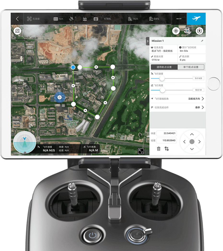
Mission-Critical Flight Simplified
Enhance your drone operations with the DJI Ground Station Pro (DJI GS Pro), an iPad app. Conduct automated flight missions, manage flight data on the cloud, and collaborate across projects to efficiently run your drone program.

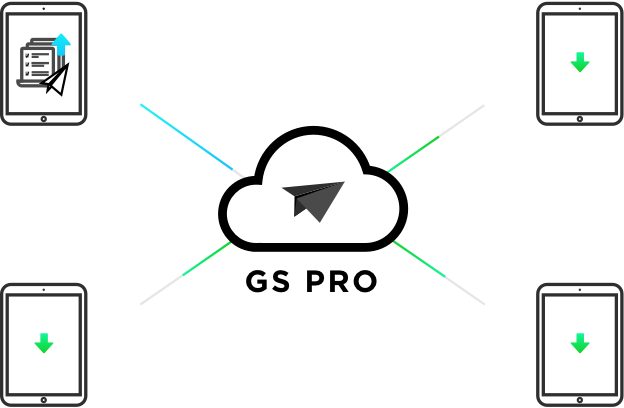
Flight Data Management
Back up flight data securely on the cloud, giving missions higher reliability and accuracy.
Reference historical information on flight missions, aircrafts, members, and flight logs so that workflows can be optimized.
Flight mission data is visible to all members of a project team, making data sharing easier.
Members can view edits made by other team members, or duplicate flight parameter settings for new missions.
Fleet and Pilot Management
Manage pilots and drones through the creation of teams, making missions more coordinated.
Designate roles with different permissions to improve communication.
Track the status of aircrafts to make proactive purchasing and maintenance decisions.
Project Management
Improve the efficiency of your drone operations by tracking individual projects and streamlining the project management process. Access to project status can be granted on a per project basis so that critical data is only available to the relevant members.
3D Map POI
Generate detailed maps of tall structures using 3D Map POI. Simply choose the subject and set a distance between it and the aircraft. DJI GS Pro will then provide relevant parameters including speed and time required to circuit the structure. Images captured can be exported into 3D reconstruction software to create accurate 3D models of the entire building.
3D Map POI excels in gathering the critical data of a structure, and is especially useful for measuring tall skyscrapers and towers. Just tap the structure on the screen and enter its basic parameters, then GS Pro will direct the drone and camera to gather the precise data you need. Through a number of customizable features like Circle and Vertical mode, 3D Map POI provides complete accuracy for effective structural management.
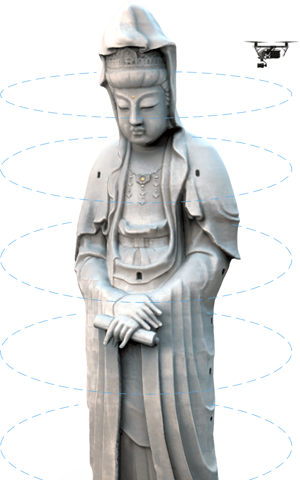
Circle Mode
After setting the drone's altitude range and flight radius, photo overlap ratio, and the structure’s radius, GS Pro will prompt the aircraft to fly in a circular path around the structure at different altitudes from top to bottom, using its photos to generate a composite 3D image according to the user’s settings.

Vertical Mode
After setting the drone's altitude range and flight radius, photo overlap ratio, and the structure’s radius, GS Pro will prompt the aircraft to follow a vertical flight and shot path along the structure, automatically relocating to the next path until it can generate a composite 3D image according to the user’s settings.
Vertical mode operates in three shooting modes:In Hover-and-Capture mode, the aircraft will calculate an increased number of waypoints that create vertical paths, and hover at each one, capturing images at maximum shot stability.In Capture at Equal Distance Interval / Time Interval mode, the aircraft will continuously fly along the main path, shooting at equal distance or time intervals while moving along vertical paths for faster operation.

Safety Instructions
- In Circle and Vertical mode, the aircraft will fly in a straight path between waypoints, so the actual distance between the aircraft and the structure may sometimes be shorter than the preset flight radius. During Capture at Equal Distance/Time Interval mode, the aircraft will fly along a parabola and the distance to the shooting target may be longer than the preset radius, so please make sure the surrounding area is open and large enough to avoid collision risks. To ensure flight safety, operators on the ground should move along with the aircraft to maintain line of sight as the aircraft flies around the structure.
- In Vertical mode, the aircraft will fly up and down many times at a relatively low speed (1~4 m/s, although speed varies from different aircraft modes), which will lead to a longer shooting time and faster consumption of the battery level.
- When resuming operations in Circle or Vertical mode, the aircraft will first ascend directly to a height equal to the previous waypoint, then fly towards it. To avoid collision risks, be sure there are no ceilings or buildings above the aircraft.

IMPORT KML/SHP Files
Increase your construction mapping efficiency by importing KML/SHP files into GS Pro. KML/SHP files, which contain important geographic information, can be imported into GS Pro via a PC or Mac wirelessly, or directly from within an iPad. After the geometries have been successfully imported, users can swipe left on the geometry list in the Map Panel, and GS Pro will automatically generate a flight mission according to the geometry field, helping users to conduct mapping with accuracy and ease.Mapping with GS Pro becomes even more flexible by adjusting waypoints. If GS Pro fails to generate a geometry similar to the target building or sets a flight route that’s not able to deliver a good result, users can still manually adjust the waypoints by dragging or add new ones to meet their needs.
Importing Geometries of a Target Building
Swipe the KML/SHP file you want to the left, and tap “Import”. GS Pro will automatically process the file and generate geometries in the “Map” folder.
Creating a Flight Mission
Swipe a task in “Map” folder to the left and tap “Create Mission”. Choose a mission type and a flight mission will be created automatically.
Notes:
1. GS Pro supports KML, SHP, KMZ, and ZIP formats and automatically decompresses KMZ and ZIP files when importing from an iPad.
2. GS Pro can generate polygons, line strings, and points. Points cannot be used to create a flight mission, yet can be used as a reference for GCP (Ground Control Point) setup.3. Currently, WGS-84 is the only coordinate system supported by GS Pro.
PhotoMap
The newly-added Photomap function helps users efficiently create aerial photograph-based maps. After users complete an aerial photography mission in the desired area and import the photos into GS Pro, the software will automatically create a composite photo of the area that users can adjust as needed.
Import Photos
After taking the required amount of photos in PhotoMap mode, users will be prompted to import them into GS Pro. To import photos, users can either download them from the aircraft via DJI GS Pro or import the photos directly to the iPad first and then open in GS Pro. Due to slow download speeds, we suggest users use an iPad SD card reader if importing a large number of photos.
Create a Map
Tap a material in the Material list, enter the material editor and then choose the photos you will use to make the composite. Tap the Compose icon on the top right corner of the screen, initiating the process. When complete, a red dot will appear on the Map tab. Tap the Map tab, where you can see all your composed maps.
Manage the Map
Tap the Map list and choose a composed map for viewing. Swipe left to calibrate, pin, or delete the map.
Calibrate the Map
Due to positioning deviation during the flight mission and limited photo image quality, the composed 2D map will inevitably have a degree of bias. Calibration helps to compensate the bias by letting users mark three or more calibration points on the map, obtain their actual GPS locations and then calibrate the map in GS Pro. Generate a control point by tapping onscreen. After marking three or more control points, tap the Calibrate icon on the top right of the screen. Once complete, a calibrated map will appear.
Virtual Fence
Virtual fence defines a specific area of flight and is useful in scenarios where some areas of a site are no-fly zones or if flight should only happen within one area, such as during manual pesticide spraying or flight. It is also useful in pilot training situations. As the aircraft approaches the virtual fence, it will brake and hover to ensure it stays within the flight area.
Industrial Applications
DJI GS Pro is a powerful, convenient and easy to use tool. With just a few taps on an iPad, complex flight routes can be created, giving critical missions added accuracy and reliability. DJI GS Pro is an indispensable tool that is capable of dramatically increasing efficiency in a wide range of industries.
- Architecture
- Precision Agriculture
- Electrical Inspections
- Aerial Imaging
- Safety Control
- Search and Rescue
GSP Ground Station PRO
- Phantom Series
- A3 / A3 Pro
- Inspire Series
- Zenmuse Series
- N3
- Matrice Series
COMPATIBLE PRODUCTS
DJI GS Pro is compatible with the following DJI aerial platforms and flight controllers:
Mavic 2 Enterprise, Mavic 2 Pro, Mavic 2Zoom, Mavic Pro, Phantom 3 Standard/Advanced/Professional/4K,
Phantom4, Phantom4 Pro, Phantom 4 Pro V2/Advanced, Phantom 4 RTK,
Matrice 200 V2, Matrice 210 V2, Matrice 210 RTK V2, Matrice 210, Matrice 210 RTK, Matrice 100,Matrice 600/Pro, Matrice 200,
Inspire 1/Inspire 2, A3, N3
Compatible cameras:
Mavic 2 Enterprise, Mavic 2 Pro, Mavic 2 Zoom, Mavic Pro, Phantom 3 Standard/4K/Advanced/Professional,
Phantom 4/Pro, and Zenmuse X3, X5, X5R, X4S,X5S, Z3, Z30, XT, XT2 and Mavic 2 Enterprise Dual.